Welcome to WxChaser.com! |
|
|
|
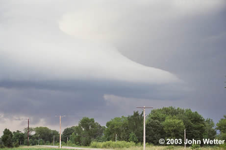
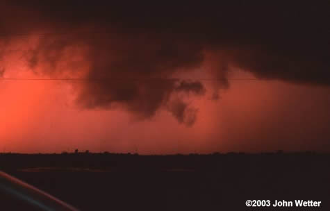
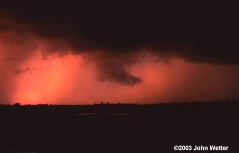
June 28, 2003 Hanover, MN Wall Cloud I had a family reunion at my parents place just west of Hanover for the afternoon, so I wasn't able to watch anything throughout the day. Everyone had pretty much left and we were talking and shooting off a few fireworks.... I looked to the Northwest, saw a pretty cool storm coming in! We were looking at it, and I thought it had what looked to be a wall cloud under it at times. I went in to check out the radar, and we were in a Tornado warning, and had been for 15 minutes! None of the sirens in the area had blown yet. So, my brother and I jumped in my car and drove north on some side roads toward Monticello. Set up on tripods to watch a gorgeous wall cloud (another shot) come in! Reported it to MPX via phone, as they weren't on any repeaters at the time. We then moved through Hanover and set up again on a hill. As the rain approached we moved farther south and east toward Burschville. Set up, and saw a very fast rotating wall cloud forming. Called this in to MPX also. We went through Burschville and headed through Corcoran, where the sirens were sounding. After Corcoran, we went south to 55 to get south and east. On the way out of Corcoran we saw a very nice funnel cloud that persisted for a minute or two. Called this in to MPX as well. As we moved on 55 east and then 101 south, the wall cloud became more ragged. We continued south and east zig-zagging and got a VERY nice shot of the wall cloud in the background with the Carlson towers in Minnetonka! We continued ahead of the storm and ended up in Eden Prairie. There was a spotter report of a wall cloud in Eden Prairie at this time. Metro Skywarn was asking for confirmation. There was a lot of ragged cloud movement, but the storm was very much outflow dominant by this time. So, Paul and I continued to get some stills and video over the top of the Vikings training center! Over-all, it was a perfect chase. It was on my home turf, so I knew every little back road to take and was able to stay just south of it the entire time. Really one of the most photographic storms I've seen in a while. Got 2 rolls of film shot, only one of which was Velvia unfortunately, and 30 minutes of video. It was also cool to see all of my reports coming out in the NWS products, I do have to say... |